Tree in the Trail Map

Tree in the Trail with Map

At the end of the summer, my poor little third grader couldn’t stand not doing school any longer, but his poor teacher wanted every minute of break possible, but I can’t hold out when kids beg to do school! We read the book Tree in the Trail a few times and then colored in this map together with the assistance of his older brother. It was a fun story and a great geography lesson.

Hand Colored Tree in the Trail Map


Beautiful Feet offers an entire geography course based on four of the Holling C. Holling books and make and sell the corresponding maps. The maps are beautiful, but I didn’t feel like making an entire unit study at the time, so we just read the book and looked at an atlas to figure a few things out that were mentioned in the book. Sometimes keeping it simple is best, at least for me.

Geography Notebook

Sometime ago, we started making a Geography Notebook. We started out by learning a few of the basic geography terms and locations–such as, North, South, Tropic of Cancer, hemisphere, etc. The main book we used was one that we checked out from the library called, Geography From A to Z: A Picture Glossary. This is a fun and easy book to learn basic geography terms from, partly because the illustrations are so nice. We also checked out and read the book, Maps and Globes by Jack Knowlton. This also has nice illustrations and simple text to help us understand how to read maps and globes. We enjoyed this book too, but the first one was more of a favorite.

All three of my older children joined in this endeavor, even the preschooler. Here are some pictures of the covers. Each one has at least one picture of Earth and then they each have a compass rose fold-up book. I can’t remember the name of this fold for my lapbook buddies, sorry. We just folded each of the four corners into the middle.

Front Page of Geography Notebooks

When you open up the compass books there is a map inside. Here is a picture of JD Boy’s hand-draw map of our culdesac.

Map of Culdesac

We also have some pages on Latitude and Longitude. All of the Latitude pages are available at my Homeschool Launch profile. Here is the link to these Latitude Notebook Pages.

Lattitude

I made this layered book of the important latitude divisions with G’tums, my preschooler. Each division is it’s own layer. This one is also available at Homeschool Launch. Here is the link.

Layered Latitude Book

Zippy designed her own Longitude/Prime Meridian page. But I designed JD Boy’s and it also can be downloaded from my Homeschool Launch profile. Here is the link to that file.

Prime Meridian/Longitude Pages

We also worked through this glossary of geography terms. This page is from the Homeschool in the Woods World Maps CD.

Geography Vocabulary

Now that we have all these terms learned, we are working on learning about places. We are having even more fun with this part. We have been reading some interesting stories and biographies about different countries, but I will save that for another post…or several.

Unplanned Social Studies–In Mexico

We were very privileged to take another vacation in Mexico this year. I am still battling some days with morning sickness, so it wasn’t as active as some of our previous years, but we still had fun and some adventure.

We like to learn about how the people live down there and what things are the same and different from the way we live. I think that is the best way to learn social studies–experience it. On this trip, we had the opportunity to have a social studies lesson that was totally unplanned. We got to experience a Mexican hospital first hand.

The second day that we were there, it was raining. My husband and I were a little disappointed because we had visions of soaking up sun. It didn’t bother the kids at all though. Their idea of fun in Mexico is to play in the water, and rainwater qualified. They put on their swimsuits and splashed to their heart’s content. Unfortunately though it all ended very abruptly. JD Boy slipped and fell on the slick, wet tile and bit a hole clear through his lip.

My husband and I debated for awhile what we should do. We ended up taking him to a hospital named Ameri Med. We thought that going to an American hospital would be the thing to do. It was false advertising. While the receptionists and billing folks spoke excellent English, the doctors and their assistants did not. My husband was the only one allowed to accompany JD Boy into the exam room. He speaks no Spanish. I’m not too sure why they didn’t send one of the receptionists back to translate or allow my husband’s grandfather to accompany and translate, but anyway, that was the way it happened.

The doctor tried to explain to my husband what his options and the prices would be. "Suturos" were 4000 pesos. After my husband asked about glue, he said "Derma  Bond" was 1700 pesos. He chose the glue and thought it wouldn’t be too expensive, but we later learned that that was only half of the charges. We were also charged for the "servicios". All of it came out to around $300US. I concluded that the "Ameri" part of the name wasn’t because the care given was American type care, but that the prices were American.

Once they settled on the Derma Bond, the doctor looked real close at JD Boy’s lip, pinched it together and the assistant smeared glue on. And that all went faster than you can read that sentence. My husband was shocked. He was expecting that they would clean the wound, but once it was glued, it was too late. No hydrogen peroxide. No iodine. No alcohol. No water. Nothing. They were done.

We were very concerned about infection. In a place where sanitation is an issue, it seems that they would be even more careful to disinfect wounds than we are, but not so. On our way back from the hospital, we stopped and purchased some hydrogen peroxide and had JD Boy rinse his mouth several times a day until we could tell that it was healing and that the possibility of infection had cleared up.

His wound looks good now. The inside is healing and there is a minimal scar on the outside. So I’m glad we took the route we did.

Last year, when we went down, I took JD Boy to a Mexican dentist and we were intrigued by Mexican dental care. This year we took him to Mexican hospital and were concerned about Mexican health care. If we go next year, I’m hoping that we can learn about something totally different and that maybe we can plan our social studies’ experience rather than having it as the result of an accident.

JD Boy refuses for me to post any pictures of his wound. I didn’t take any of the hospital for fear of getting in trouble. It looked fairly normal though, at least the waiting room, which was all that I got to experience. However, I have a few shots from just around town, that I thought were interesting.

Cathedral in Puerto Vallarta, Mexico

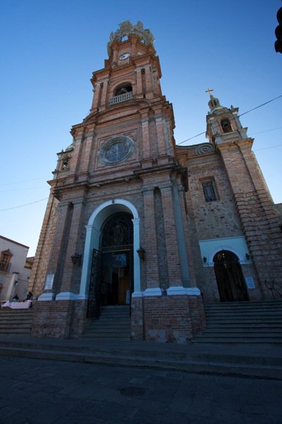
The Cathedral in Puerto Vallarta, Mexico.
While Mexico has no official religion, 89% of the population is Catholic. There are services and activities going on at this Cathedral all the time.

Electric lines by Cathedral in Puerto Vallarta, Mexico

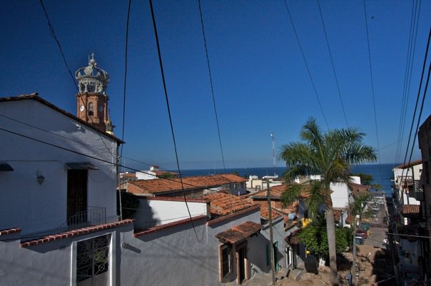
Electric lines close to the Cathedral.
You can see the Cathedral in the distance. The infrastructure, even in this town that runs mostly on tourism, is poor. This isn’t even the worse case of spider-web lines that we saw. The roads are also poorly maintained. Right now they’re repainting and remodeling all the store fronts in certain parts of town. The locals think that there must be some event planned that they just haven’t heard about yet.

Playground equipment in Puerto Vallarta, Mexico

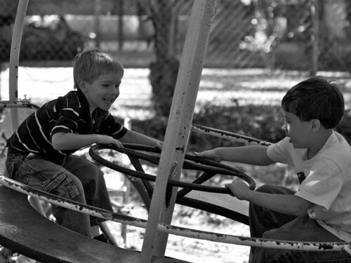
Playground equipment.
The playgrounds aren’t covered with lawn. They are covered with dirt. You can see that the equipment isn’t super well maintained either, but my boys thought it was a blast to play on anyway.

Stay tuned for pictures from our nature study while we vacationed. I can’t wait to share them with you.

Geography on Vacation

I think that learning geography when you’re traveling should never be skipped. What better way to learn where something is than go there? Several people have asked where we went. We were just south of Puerto Vallarta. My daughter plotted our flight path on a map. We had to avoid bad weather or some type of turbulance on the way down, so we were routed way inland. That made it a little more interesting. The pilot would announce what city we were flying over periodically, so that was fun and enhanced our geography lesson while we were travelling.

Here is her map.

Zippy's Map of Route to Mexico

For those of you who are now so curious about the Puerto Vallarta area, I found this website that has some interesting info for tourists. Here is the map from that website.

We were down by the Mismaloya/Boca de Tomatlan area.  If you are looking to travel there for any reason, I would highly recommend checking into Mismaloya. There is a nice hotel there. I’ve never stayed there, but I’ve walked around and in it to check it out before. I just like that it is away from the city out there and it is easy to go out to the beach. You can easily catch a water taxi (a boat) and go to villages that have no roads into them. All the travel into these villages is either by water taxi or mule. However from Mismaloya it is not so easy to go grocery shopping, but they have a good bus system there, so it’s not too bad.

This was actually my ninth trip to the area. One of those trips was our honeymoon. You might guess that we love it there! We are very fortunate to have family with a house there and so we have wonderful accomodations when we go down. We have stayed three times in time share though, in Puerto Vallarta and up in Nuevo Vallarta. In my opinion, the neat things to see are not at the resorts, although they’re a nice place to stay. So figuring out a way to get out and about is important to be able to see the habitat and the area around there.

My one, last comment about the area is save your shopping for at home. If you can get away from Puerto Vallarta out to some small villages on their market day, shopping can be interesting. I once purchased a Mexican blanket at one of these markets when we were driving up to San Blas that I really like. (San Blas is another really awesome spot for birding.) I had priced the identical blanket in Puerto Vallarta and it was  double the price there as to what I paid in the village. Of course, you have to “bargain” with them, but even then that was their “best deals” compared.

So my travel advice is, if you were to ever go, find some form of transportation, even if it’s the bus, and get out and see things away from where all the tourists are huddled together. You’ll really enjoy it, at least, we do.

Where are we?

We are on vacation! Vacation always provides some really wonderful learning opportunities that just don’t pop up when you are at home. Just think of some the things that are perfect to study when you are away from home: geography, social studies, history and nature studies, etc. We are having so many great opportunities to learn. (Besides that we are soaking up some much needed sun!)

I hope to post several of the things we are learning over the next few days, but today, I thought your kids might like to guess where we are. Have your kid(s) look at the picture below and figure out where we are. If they leave me a comment before I make my next post telling me where we are, I will get a postcard for them and mail it when I get home. I would mail it from here, but I’m not sure that they have mail here. I don’t think they’ve got that system quite figured out yet.

Flag